Subscribe to Get Updates
For periodic Oriient updates only, no spam - ever.
Oriient’s secret sauce is Earth’s magnetic field. Leveraging magnetic data collected by sensors found in smartphones provides unparalleled indoor navigation, deployment, and scalability for any building, removing the cost and hassle of installing physical hardware.
A software-only solution delivers many benefits – smoothing procurement and deployment and reducing ongoing costs, among others. Having a speedy deployment process allows Oriient customers to activate their Indoor GPS quickly and effortlessly (we activated our services in 300 locations in a single month).

Here is a sneak peek into Oriient’s patented magnetic mapping process required for activating a new building and starting to position users accurately indoors.
Magnetic Mapping
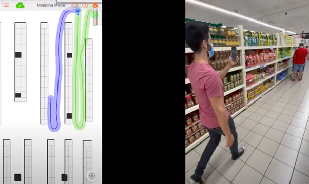
Magnetic mapping is the process of collecting magnetic data from the inside of a building. This data can then be used to analyze an app-user’s reading and activity, making it easy to find their location.
When mapping out a new building or store, an Oriient mapper walks through the site to capture the magnetic reading around the space while marking their position on the floor plan. This recording captures the “magnetic landscape” of the building, which is overlaid on top of a visual map.
The building owners then offer their visitors and staff a mobile app with Oriient’s SDK integrated. Now supported with Oriient, the app can then track user location (just like with a GPS location), offering real-time navigation, location-based actions, and traffic analytics.
Currently, the mapping process is fulfilled by Oriient’s extensive network of partners, who are remotely supervised by the Oriient Mapping Center team. You may not notice the mappers in your store, because they look just like any other customer walking around with a smartphone in their hands, and they never disturb visitors or interfere with venue operations. In fact, they may even go out and do some shopping when they’re done!
Moving Forward
As the next step, Oriient will allow its customers to map their facilities on their own, leveraging the workforce already on-site.
An associate will be able to activate their facility themselves, starting with light training and a user-friendly app (think of a “wizard”), while being remotely monitored by Oriient.
With time, more tools will be added, to make it even simpler- without any guidance – so all that’ll be needed is to walk around once.
Mapping the Future
“Our long-term goal is even more ambitious,” shares Uri Tzadikevitch, VP of Product at Oriient. “Mapping will occur automatically anytime someone walks into the building. The app will be running as usual, just with Oriient’s service activated in the background. Once the entire space has been walked by normal traffic, the site will go live. Essentially, Oriient’s indoor navigation will become like Waze, where the buildings are mapped automatically by crowdsourcing.”
The automated-mapping future will unlock a seamless and scalable way to activate indoor navigation anywhere. Instead of mapping 300 sites in a month, 300 sites will be mapped in an hour – to align with Oriient’s vision of powering all commercial buildings in the world with IndoorGPS.
